
Dr. Jerome Songcuan, a faculty member of the College of Computer Science (CCS), has developed another mobile application, this time named JUAN.
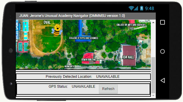
JUAN is a mobile app whose purpose is to identify the user’s location inside DMMMSU-SLUC without having to connect to the internet. Dr. Songcuan used a bee animation to indicate the current location of the user. He adopted it from DMMMSU’s ‘stinging bees’.
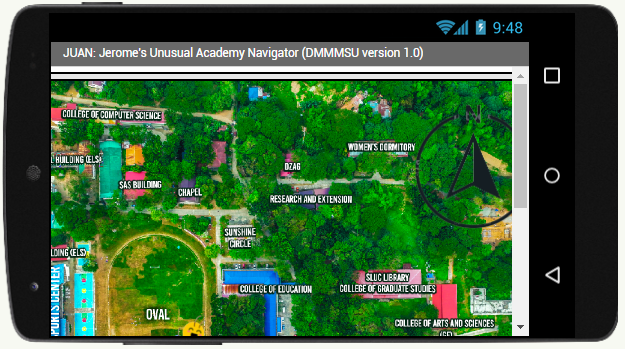
The mobile app was further reprogrammed and was used during the CCS Amazing Race, one of the fun highlights of CCS Week 2023 held last week. The goal of the game is to locate as many BeeCoins hidden in DMMMSU Agoo Map. The developer hopes that the players especially the freshmen will be acquainted not only with the locations of important buildings in DMMMSU-Agoo but also with that of the employees working in the different buildings. The thrilling part of the game is that the users become familiar with the locations of buildings and that of the faculty members and staff. They can also benefit from the physical movement required in the game as they need to walk to locate BeeCoins. This app finds its relevance in the academic community as the specific location of offices and buildings in the Campus can already be easily identified. Questions on locations of offices are commonly asked by auditors from other Campuses during audit interviews; in the same way, other visitors can already receive this type of information from students and users of the app when visiting Agoo Campus for the first time. Furthermore, the mobile app’s flow can be easily redesigned to suit other maps as the need arises.
Dr. Songcuan started working on the app in December of last year and converted it into CCS amazing race last March 10. Dr. Songcuan says he was inspired by Google maps and Waze but he tweaked the app by making it independent on the internet. Dr. Songcuan was thrilled as he recalled his and his partners’ experience while developing the app.
“Inspired by the concept of Google maps and Waze, we tried to create a local map that does not depend on the internet, only GPS signal from satellites. From there we tried to experiment. Lakad lakad lang kami buong campus to locate GPS coordinates na para kaming mga baliw. Then we asked students to use the app and revised the code based on their comments. And the rest is history.”
Dr. Songcuan also underscored that the app can still be further improved. “More importantly, I am happy to share that some of our senior Computer Science students are inspired to develop app based on our out-of-the box concepts,” he concluded.
Dr. Songcuan acknowledges the help of his team whom he works with in the Application Development Lab Team in his College. They are Dr. Richard Marzan, Dr. Enrique Abad, Mr. Ezekiel Bacungan, Mr. Anthony Imatong, Mr. Jon Kalvin, Mr. Louis Philip Facun. As for the aerial shot and labeling of the map, he received help from the members of the Multimedia Lab – Ms. Jeseca Baculo, Ms. Nema Rose de Vera, Dr. Belinda Dungan, Dr. Joe Anthony Milan, Dr. Clarissa Albarillo, Mr. Charlie Marzan, and Ms. Emely Munar. (By Ayu)
For instructions on how to use the map, see the attached screenshots and answer sheet below using the link : https://rb.gy/6ou3ss